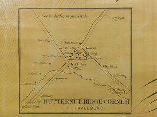
At first glance, the Walling Map of 1862 looks like an
ordinary map of Saint John and Kings County, albeit large and old, but upon
closer inspection you can see that it is no normal map. Our topographical map is
one of only a few from that period, as documented by Sandra Devlin, a
veteran journalist (and self-confessed genealogy addict) in her newspaper
article titled “Pinpoint your ancestors on the map”:
“According to the Canadian Institute of Geomatics: six
counties in New Brunswick were mapped first between 1862-1876, namely: Albert
and Westmorland, 1862, by H.F. Walling; Carleton, 1876, by Roe and Colby;
Northumberland, 1876, by Roe and Colby and St. John and Kings, 1862, by W. E.
and A. A. Baker.”
 Our Topographical Map of the Counties of St. John and Kings
was published in 1862 by W.E. & A.A. Baker, with the survey under the
direction of H.F. Walling. This map not only shows the topography of the two
counties but also gives the business directories for its communities, such as
the bustling district of Springfield which during 1862 boasted two boot and
shoe manufacturers, as well as five school teachers. Most interesting for
genealogists, however, is the inclusion of the names and locations of numerous subscribers
from these communities, people who sought to ‘leave their mark’ for posterity
through this map.
We’re glad they did.
The Norman B.
Leventhal Map Center at the Boston Public Library has an excellent scan of
this map which you can use to zoom in for a more in depth view of where the
person’s residence was, similarly to how you now would have town and city names
marking their locations on a map. Beyond land grants and censuses it can be
difficult to pin point where your ancestors actually lived, but this map
provides a snapshot in time for many families and it is an invaluable tool for
genealogists and researchers seeking to understand the communities of their
ancestors.
In her article, “The Walling Map: An old map put
together by H.F. Walling, offers detailed information for genealogists,” Ruby
Cusack tells the following story about the Walling map's production:
“The late Harold Beyea told Bill Titus an interesting story
concerning the compilation of the names on the Walling map. The compiler is
said to have walked the roads of Kings and Saint John counties, pushing a
wheelbarrow that contained his kit of materials and the wheel had a measuring
device to record distances. He would stop at each household or business for a
subscription for their name to be placed on the map. Barter was prevalent in
those days, so often a meal or night's lodging was exchanged for his service.”
Inclusion on the map was dependent on this paid subscription
and, as a result, not every family in 1862 could afford to be a subscriber. But
Kings County residents were resourceful then, as now, and it is funny to imagine
the barters and trades they made – including having the survey man stay overnight
at your house - in order to get their name on the map.
They certainly were a determined lot, destined to leave
their mark on Kings County.
Thanks to Ruby
Cusack, the Norman B. Leventhal Map Center
at the Boston Public Library and Sandra Devlin’s newspaper article “Pinpoint
your ancestors on the map” for insight into this amazing artifact, and to summer staffer Lydia Blois for writing this post!
To purchase reproductions of this map (or sections) locally,
contact Paul Anderson of Fredericton at vintage@nbnet.nb.ca


Great post of a great research tool at Kings County Museum!
ReplyDeleteI have one of the originals 4'x4' with scroll for sale
ReplyDelete